Asheville got 3.81 inches of rain Saturday, a record for Oct. 10, as Isaias's remnants passed. Rivers in the city stayed below flood stage; sun returns Monday.
Updated Oct. 17: The French Broad River near Fletcher was back down to 4.67 feet late Friday, well below the 10-foot action stage, on the weather service gauge. DriveNC no longer lists flooding on the Broadway ramp to I-240.
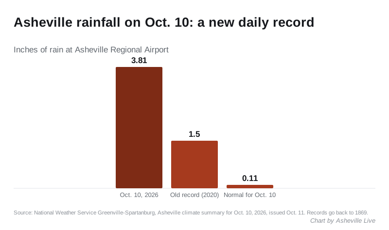
Asheville had 3.81 inches of rain Saturday as the remnants of Isaias moved through. That is the most ever recorded in the city on an Oct. 10.
The old record was 1.50 inches, set in 2020. The normal rainfall for the date is 0.11 inches. The figures are in the National Weather Service’s Asheville climate summary for Oct. 10, issued early Sunday by its office in Greenville-Spartanburg, South Carolina. Asheville’s weather records go back to 1869.
Another 0.60 inches fell Sunday, according to the weather service’s summary for Oct. 11. That brings October’s total to 5.25 inches through Sunday. A normal October has had 1.29 inches by this point.
What the rivers did
The rain did not push the rivers in the city into flooding. Readings from the National Water Prediction Service gauges show:
| Gauge | Sunday peak | Weather service action stage | Flood stage |
|---|---|---|---|
| French Broad River at Pearson Bridge Road, Asheville | 6.17 feet, about 11 a.m. | 6.5 feet | 9.5 feet |
| Swannanoa River at Biltmore Village | 5.42 feet, about 10 a.m. | 9 feet | 10 feet |
| French Broad River at Old Fanning Bridge Road, near Fletcher | 11.75 feet, about 12:30 p.m. | 10 feet | 13 feet |
The gauge near Fletcher, about 10 miles south, is the one to watch. It was still at 11.59 feet, in the action stage, at 1:45 a.m. Monday. The weather service forecast it to ease to 11.1 feet by 8 a.m. Action stage is below flood stage.
Warnings and roads
The weather service in Greenville-Spartanburg had Buncombe County under a flood watch from 8 a.m. Saturday until 2 p.m. Sunday. Its Saturday evening update expected 2 to 5 inches of rain across most of the watch area, and 5 to 8 inches along the Blue Ridge Escarpment.
A high wind warning covered elevations above 3,500 feet until 8 a.m. Sunday, with gusts up to 60 mph forecast. A wind advisory covered lower ground. At the Asheville climate station the strongest gust Saturday was 22 mph.
DriveNC, the N.C. Department of Transportation’s traveler site, listed flooding Sunday on the ramp from Broadway to westbound I-240. The listing started at 4:48 a.m. Sunday and was set to end at 9:45 a.m. Monday. Check the road construction and closures page for state work zones.
What the city and county said
The City of Asheville said Saturday there were no impacts to city services, events or programming. It said Water Resources had finished its storm preparations and transit would run on a normal schedule.
Buncombe County posted an updated summary of weekend weather impacts on Sunday. The county’s website did not load for us Monday morning, so its contents are not in this story.
What it means for you
- The rain is over. The weather service forecast for Asheville calls for patchy fog early Monday, then mostly sunny skies and a high near 76. Tuesday is forecast sunny, with a high near 82.
- Near the French Broad south of the city, expect high water through Monday morning. Never drive through water over a road.
- Sign up for alerts. The city’s AVL Alert system sends the city’s emergency notices.
- Lost power or saw a line down? Our power outages page has who to call.
Have your say